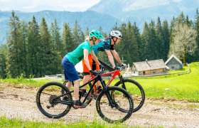
Nomen est omen - the Bikercountry Hollenstein really has to offer, what the bikers heart desires. Attractive mountain bike trails in a fantastic landscape. The Sonnbrand - a mountain tour with the additional variant Alpine tour should be driven at least once by a Mountainbiker. And once having driven the route, then you will want to drive it again and again. With the best of what lower Austria has to offer!
Description
Hollenstein an der Ybbs - Promau - Sonnbrand Alm - Garnstatt - Rotmoos - Eisenwiesen - Promau - Hollenstein an der Ybbs
Starting point of the tour
Hollenstein an der Ybbs, Main Square
Destination point of the tour
Hollenstein, Ortszentrum
Route description Sonnbrand-Almtour
Starting point in the Centre of Hollenstein/Ybbs on the MTB information booth on the Raikaplatz (place), along the romantic hammer Valley the trail slightly ascends into the nature park of lower Austrian Eisenwurzen, past at the Treffengut- and Wentsteinhammer (relics of the blacksmith's hammer time, refreshment and panorama stop) steadily uphill past the old hunting lodge Sandgraben up to the road junction Promau (at km 9.5), continue straight on a forest road past a large wildlife feeding station up to the junction Kitzhüttenstraße (here the Kitzhütten-Alpine tour branches off) turn right along Sonnbrand-Straße on the south side of the Königsberges, at the Holzknecht- and Jagdhütten (cabins) there are views on to the Hochkar, Dürnnstein and Ötscher up to the junction Granstatt (at km 21.1). Now the trail goes up a strenuous climb to the Alpine tour, to the Siebenhüttenalm (cabin) (managed from June to September), where you can take a well-deserved rest. Now continue along the ridge of Königsberges to the highest point of the tour, Schwarzkogel (1405 m) with a unique view of the Eisenerzer Alps, Hochschwab, Gesaeuse mountains, from the Totes Gebirge (mountains) up to the Waldviertel, and not far away the area Ötscher Dürnnstein - Hochkar-Gamstein-Voralpe, continue across Vierhütten to the end of the forest road, then cut across the Daucheralm up to the separation of the two pasture areas, return to the forest road and continue slightly downhill to the Königsberghöhe. Here, a detour to the Kitzhüttenalm (cabin) with its rustic owner Gerhard recommended. Open from June to September, it offers a cosy mountain snack with special cycling drinks. After extensive rest the tour begins its way back, slightly uphill to the Königsberghöhe, and from the downhill departure countdown begins, at half-height the descent begins right past the Kastner Gschlief, via the Kitzhütten-Almtour, to the Thomasbergerboden (meadow), steeply downhill through some rough dirt roads to the Königsbergliften (lifts) past the Trout Pond - here the Jausenstation Haslinger (inn) offers from Friday to Sunday Mostviertler specialities - after approximately 100 metres do we turn right onto a dirt road through the Berry Heath, and from the farmhouse Rain, does the asphalt road lead past the school back to the starting point. If the weather allows one can after the Tour at the Ybbstrandbad, one of the last river baths, rest and refresh.
Directions
A1, exit Amstetten West, Ybbstalbundestraße Direction Waidhofen an der Ybbs, Waidhofen, Opponitz to Hollenstein
Alternative: A1, exit Ybbs/Wieselburg, Erlauftalbundesstraße direction Wieselburg, Wieselburg, Scheibbs, Gaming, Lunz am See, Göstling to Hollenstein
Author's tip
Hollenstein/Ybbs:
Riding on the Königsberg, swimming in one of the most beautiful River baths on the Ybbs, hike along the Hollensteiner Sagenweges (from Göstling to Hollenstein), trip to the Kitzhüttenalm (cabin) und Siebenhüttenalm (cabin), (managed from June to end of September)
Information on the municipal office Hollenstein
Göstling/Ybbs:
"Auf dem HOLZweg" is the theme of the theme world Mendlingtal, with the unique wooden drift facility, the romantic gorges, the Hermitage, the old flour mill, and the bread bakehouse
the trout ponds, the Hammerherren-gasthaus (guest house), and much more.
Information at the tourist office Göstling Alps


